Tropical Weather Update:
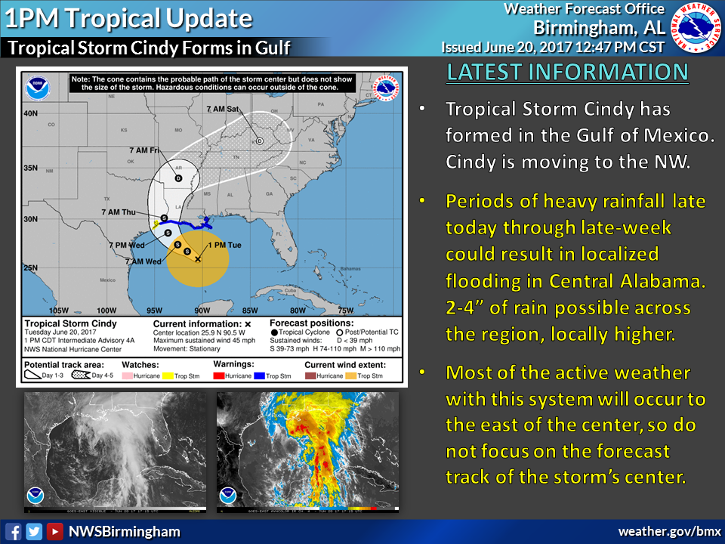
The following information is from the National Weather Service in Birmingham, AL. Please find the current Hazardous Weather Outlook (HWO) and the current graphic on TS Cindy’s location and projected path. Though we will not feel the full effects of Cindy’s wind. We will still see heavy bands of rainfall from 1 to 1-1/2 inches of rain per day across the region. With totals of 2 – 4 inches of rain possible in Central Alabama through Thursday evening.
Elmore County EMA will continue to monitor this Tropical event and will send out updates as necessary. For Hurricane Preparedness Information check our website at: www.elmorecoema.com
Hazardous Weather Outlook
National Weather Service Birmingham AL
1201 PM CDT Tue Jun 20 2017
ALZ011>015-017>050-212015-
Marion-Lamar-Fayette-Winston-Walker-Blount-Etowah-Calhoun-Cherokee-
Cleburne-Pickens-Tuscaloosa-Jefferson-Shelby-St. Clair-Talladega-
Clay-Randolph-Sumter-Greene-Hale-Perry-Bibb-Chilton-Coosa-Tallapoosa-
Chambers-Marengo-Dallas-Autauga-Lowndes-Elmore-Montgomery-Macon-
Bullock-Lee-Russell-Pike-Barbour-
1201 PM CDT Tue Jun 20 2017
This Hazardous Weather Outlook is for the counties served by the
National Weather Service office in Birmingham.
.DAY ONE…This Afternoon and Tonight.
There is a low confidence threat for localized flooding through
tonight as moderate to heavy rains will be possible along and south
of a line from Fayette to Jacksonville.
.DAYS TWO THROUGH SEVEN…Wednesday through Monday.
Several bands of moderate to heavy rains will be possible through
Thursday across all of Central Alabama. Confidence is low in exactly
where the bands will set up during the period.
On Thursday and Friday we will see an increase in instability during
the heating of the day as the a low pressure system moves closer to
the area. This will provide the potential for brief tornadoes and
damaging winds. The highest chances will be along and west of
Interstate 65. There is still time for changes in confidence so stay
tuned.
.SPOTTER INFORMATION STATEMENT…
Activation of storm spotters and emergency management may be needed
from Thursday through Friday due to the multiple threats across the area.