Update on potential impacts from Hurricane Irma for Elmore County
Posted at 8:00 a.m. on 9-10-2017
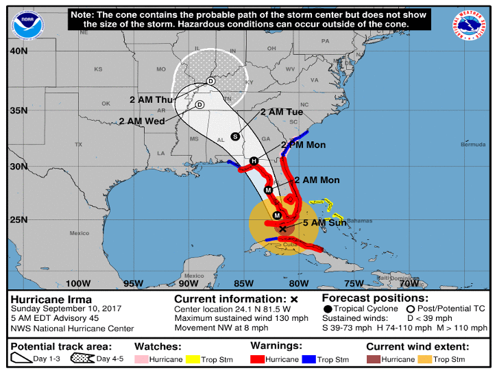
Elmore County is now covered by a Tropical Storm Warning as issued by the NWS Forecast Office in Birmingham. According to the NWS, at this point and under the current forecast, Elmore County will likely experience 20 to 40 mph sustained winds with gusts of 50 to 60 mph possible and 2 to 4 inches of rainfall may be experienced from early Monday through early Tuesday. Currently the sustained winds are forecast to increase tomorrow morning between 7:00 and 9:00 a.m. and will not subside until closer the early morning hours Tuesday morning. The closer you travel east to the Alabama/Georgia state line, 40 to 50 mph sustained winds with gust of 50 to 70 mph are possible. Below is the latest Hazardous Weather Outlook from the NWS Forecast Office in Birmingham along with a couple of the updated graphics describing the threats and timing of the weather impacts expected. Also below is the latest graphic from the National Hurricane Center on the latest track on Hurricane Irma. We will continue to send out email updates and post the updates to our website, Facebook and Twitter as the forecast is updated. Please be prepared!
Also, we have updated the Safer Places that will be opening for these weather conditions on our website for further information, please check out our website at www.elmorecoema.com
Hazardous Weather Outlook
National Weather Service Birmingham AL
718 AM CDT Sun Sep 10 2017
ALZ011>015-017>050-111530-
Marion-Lamar-Fayette-Winston-Walker-Blount-Etowah-Calhoun-Cherokee-
Cleburne-Pickens-Tuscaloosa-Jefferson-Shelby-St. Clair-Talladega-
Clay-Randolph-Sumter-Greene-Hale-Perry-Bibb-Chilton-Coosa-Tallapoosa-
Chambers-Marengo-Dallas-Autauga-Lowndes-Elmore-Montgomery-Macon-
Bullock-Lee-Russell-Pike-Barbour-
718 AM CDT Sun Sep 10 2017
This Hazardous Weather Outlook is for the counties served by the
National Weather Service office in Birmingham.
.DAY ONE…Today and Tonight.
No hazardous weather is expected at this time.
.DAYS TWO THROUGH SEVEN…Monday through Saturday.
A Tropical Storm Warning is in effect for areas east of I-65.
Hurricane Irma will track northwest through Florida today and tonight
and across central Alabama Monday and Monday night. For Central
Alabama, the most active weather, including the highest wind gusts
and heaviest rainfall, is expected generally along and east of I-65
Monday and into early Tuesday. Winds sustained at 30 to 50 MPH, with
gusts of 50 to 70 MPH are likely in the warning area. This will
likely result in scattered downed trees and some power outages.
Tropical rains are expected to bring rainfall totals of 2 to 4 inches
across east Alabama and 1 to 3 inches across west Alabama. Changes
to this forecast are possible and will depend on Irma`s track. Please
continue to monitor for the latest forecasts as Irma nears.
.SPOTTER INFORMATION STATEMENT…
Activation of storm spotters and emergency management will be likely
Monday into early Tuesday.
$$