
As of 6:00 P.M.
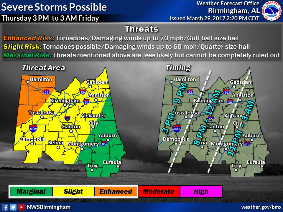
According to the National Weather Service Birmingham, Alabama, there is an increasing rain chance with a few strong to severe storms during the afternoon. Even better chances during the evening. (See the Graphic for the timing and threat concern).
Stay Weather Aware.
HWOBMX
Hazardous Weather Outlook
National Weather Service Birmingham AL
406 PM CDT Wed Mar 29 2017
ALZ011>015-017>050-310015-
Marion-Lamar-Fayette-Winston-Walker-Blount-Etowah-Calhoun-Cherokee-
Cleburne-Pickens-Tuscaloosa-Jefferson-Shelby-St. Clair-Talladega-
Clay-Randolph-Sumter-Greene-Hale-Perry-Bibb-Chilton-Coosa-Tallapoosa-
Chambers-Marengo-Dallas-Autauga-Lowndes-Elmore-Montgomery-Macon-
Bullock-Lee-Russell-Pike-Barbour-
406 PM CDT Wed Mar 29 2017
This Hazardous Weather Outlook is for the counties served by the National Weather Service office in Birmingham.
.DAY ONE…Outlook Through Tonight.
No hazardous weather is expected at this time.
.DAYS TWO THROUGH SEVEN…Thursday through Tuesday.
A threat of severe thunderstorms will come Thursday afternoon into Thursday night across all of Central Alabama. Potential threats will include damaging winds up to 70 mph, tornadoes, and hail up to golf ball size. The greatest risk appears to be for areas near Aliceville, Fayette, Vernon, Sulligent, Hamilton, and Double Springs.
A second system will impact the area on Monday as well. Potential threats will include damaging winds up to 60 mph, brief tornadoes, and hail up to the size of quarters.
.SPOTTER INFORMATION STATEMENT…
Activation of storm spotters and Emergency Managers may be needed on Thursday and Monday.
$$