ROAD CLOSURE: Joiner Rd will be closed until further notice from approximately 1/2 mile west of Hwy 9 to Loboe Rd due to muddy conditions.


ROAD CLOSURE: Joiner Rd will be closed until further notice from approximately 1/2 mile west of Hwy 9 to Loboe Rd due to muddy conditions.
The Elmore County EMA will NOT be conducting our monthly All Hazards Warning siren test this morning. The test has been rescheduled for next Wednesday, January 9, 2019 at 9:00 a.m. Thanks.
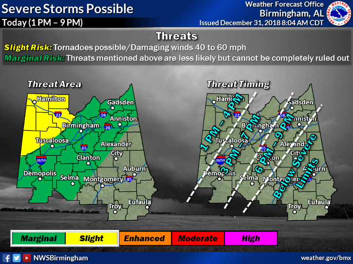
The NWS-Birmingham changed the forecast for today/tonight. They increased the potential for severe weather in the northwest counties to “Slight” and they moved the “Marginal” potential back to the western edge of Elmore County. Elmore County isn’t in the Marginal zone but we are right on the edge, so we must be aware of the potential in our area.
Also, the timeframe for the line of storms to enter Elmore County will be sometime after 9 p.m. Please refer and make any plans or adjustments for the events tonight.
We hope everyone has a safe and Happy New Year. Don’t Drink and Drive! Stay weather aware tonight!
Hazardous Weather Outlook
National Weather Service Birmingham AL
720 AM CST Mon Dec 31 2018
ALZ011>015-017>050-011630-
Marion-Lamar-Fayette-Winston-Walker-Blount-Etowah-Calhoun-Cherokee-
Cleburne-Pickens-Tuscaloosa-Jefferson-Shelby-St. Clair-Talladega-
Clay-Randolph-Sumter-Greene-Hale-Perry-Bibb-Chilton-Coosa-Tallapoosa-
Chambers-Marengo-Dallas-Autauga-Lowndes-Elmore-Montgomery-Macon-
Bullock-Lee-Russell-Pike-Barbour-
720 AM CST Mon Dec 31 2018
This Hazardous Weather Outlook is for the counties served by the
National Weather Service office in Birmingham.
.DAY ONE…Outlook through Tonight.
There is a slight chance for severe storms this afternoon after 1 pm
through tonight, around 9 pm. Areas that could be impacted include
areas along and west of a Selma to Clanton to Anniston line. Wind
gusts of 40 to 60 mph are possible with a line of showers and
embedded thunderstorms. In addition to the winds, locally heavy
rainfall is expected as well. A tornado can not be ruled out across
the far northwestern counties, or along and west of a Carrollton to
Cordova line, generally from 1 to 4 pm.
Rises along the rivers will continue and many are near bankfull or
in flood. Please refer to river flood warnings, statements, and
advisories for the latest information.
.DAYS TWO THROUGH SEVEN…Tuesday through Sunday.
Some rivers will continue to experience flooding into next week.
Please refer to river flood warnings, statements, and advisories for
the latest information.
.SPOTTER INFORMATION STATEMENT…
Activation of storm spotters and emergency management may be needed
through this evening.
$$
Flood Warning
Flood Statement
National Weather Service Birmingham AL
721 PM CST Sat Dec 29 2018
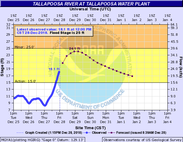
...The flood warning continues for the Tallapoosa River At The
Tallapoosa Water Plant...
.Rises continue on the Tallapoosa River...and a flood warning
remains in effect at Tallapoosa Water Plant.
PRECAUTIONARY/PREPAREDNESS ACTIONS...
Do not drive cars through flooded areas. Turn Around...Don`t Drown.
Another statement will be issued by Sunday morning...or sooner if
conditions warrant.
&&
ALC051-101-301319-
/O.EXT.KBMX.FL.W.0045.000000T0000Z-181231T1715Z/
/MGYA1.1.ER.181230T0115Z.181230T1800Z.181231T0515Z.NO/
721 PM CST Sat Dec 29 2018
...Flood Warning extended until Monday morning...
The Flood Warning continues for
The Tallapoosa River At The Tallapoosa Water Plant.
* until Monday morning...or until the Warning is cancelled.
* AT 6:00 PM Saturday the stage was 24.8 feet.
* Minor flooding is forecast.
* Flood stage is 25.0 feet.
* Forecast...Rise above flood stage by this evening and continue to
rise to near 26.2 feet by tomorrow early afternoon. The river will
fall below flood stage by tomorrow late evening.
* Impact...At 25.0 feet...Lower Wetumpka Road starts to flood.
Extensive flooding of low lands occurs and livestock and farm
equipment should be moved to higher ground.
&&
LAT...LON 3239 8609 3242 8620 3249 8626 3250 8624
3244 8616 3244 8609
$$
Flood Statement
National Weather Service Birmingham AL
728 PM CST Sat Dec 29 2018


...The flood warning continues for the Alabama River At Montgomery...

.Rises continue on the Alabama River due to recent rainfall...and a
Flood Warning remains in effect for the river at Montgomery.

PRECAUTIONARY/PREPAREDNESS ACTIONS...

Do not drive cars through flooded areas.  Turn Around...Don`t Drown.

Another statement will be issued by Sunday morning...or sooner if
conditions warrant.

&&

ALC001-047-051-085-101-301329-
/O.EXT.KBMX.FL.W.0046.000000T0000Z-190101T1300Z/
/MGMA1.1.ER.181229T2030Z.181230T1800Z.190101T0100Z.NO/
728 PM CST Sat Dec 29 2018

The Flood Warning continues for
  The Alabama River At Montgomery.
* until Tuesday morning...or until the Warning is cancelled.
* AT  6:00 PM Saturday the stage was 35.3 feet.
* Minor flooding is occurring and Minor flooding is forecast.
* Flood stage is 35.0 feet.
* Forecast...The river will continue rising to near 37.5 feet by
  tomorrow evening . The river will fall below flood stage Monday
  evening.


&&

LAT...LON 3248 8631 3236 8630 3239 8638 3232 8654
          3237 8661 3245 8636

$$
Flood Statement
National Weather Service Birmingham AL
717 PM CST Sat Dec 29 2018


...The flood warning continues for the Coosa River At Childersburg...

.The Coosa River at Childersburg has crested...and a slow fall is
expected for the next several days.

PRECAUTIONARY/PREPAREDNESS ACTIONS...

Do not drive cars through flooded areas.  Turn Around...Don`t Drown.

Another statement will be issued by Sunday morning...or sooner if
conditions warrant.

&&

ALC021-037-051-117-121-301316-
/O.EXT.KBMX.FL.W.0047.000000T0000Z-181231T1200Z/
/CHLA1.1.ER.181229T0652Z.181229T1830Z.181231T0000Z.NO/
717 PM CST Sat Dec 29 2018

...Flood Warning extended until Monday morning...The Flood Warning
continues for
  The Coosa River At Childersburg.
* until Monday morning...or until the Warning is cancelled.
* AT  6:45 PM Saturday the stage was 402.6 feet.
* Minor flooding is occurring and Minor flooding is forecast.
* Flood stage is 402.0 feet.
* Forecast...The river will continue to fall to below flood stage by
  tomorrow evening .
* Impact...At 402.0 feet...Flooding of low lying areas begins. At 404
  feet flooding of some low lying roads in the area begins...and the
  yards of some homes near the river become flooded.

&&

LAT...LON 3333 8632 3320 8643 3322 8648 3328 8645
          3330 8639 3335 8637

$$


NWS Advanced Hydrologic Prediction Services forecast graphs for the Tallapoosa River at gauge locations in Elmore County.

The NWS-Birmingham has cancelled the Tornado Watch for Elmore County.
WWUS64 KBMX 011601
WCNBMX
WATCH COUNTY NOTIFICATION FOR WATCHES 420/421 NATIONAL WEATHER SERVICE BIRMINGHAM AL
1101 AM CDT THU NOV 1 2018
ALC037-051-101-011715-
/O.CAN.KBMX.TO.A.0420.000000T0000Z-181101T1800Z/
THE NATIONAL WEATHER SERVICE HAS CANCELLED TORNADO WATCH 420 FOR THE FOLLOWING AREAS
IN ALABAMA THIS CANCELS 3 COUNTIES
IN CENTRAL ALABAMA
COOSA ELMORE MONTGOMERY
THIS INCLUDES THE CITIES OF MILLBROOK, MONTGOMERY, ROCKFORD, AND WETUMPKA.
$$
ALC005-011-109-113-011900-
/O.CON.KBMX.SV.A.0421.000000T0000Z-181101T1900Z/
SEVERE THUNDERSTORM WATCH 421 REMAINS VALID UNTIL 2 PM CDT THIS AFTERNOON FOR THE FOLLOWING AREAS
IN ALABAMA THIS WATCH INCLUDES 4 COUNTIES
IN EAST CENTRAL ALABAMA
RUSSELL
IN SOUTHEAST ALABAMA
BARBOUR BULLOCK PIKE
THIS INCLUDES THE CITIES OF EUFAULA, PHENIX CITY, TROY, AND UNION SPRINGS.
$$
000
WWUS84 KBMX 011457
SPSBMX
SPECIAL WEATHER STATEMENT
NATIONAL WEATHER SERVICE BIRMINGHAM AL
957 AM CDT THU NOV 1 2018
ALZ025-035>037-041>044-011600-
CHILTON AL-TALLAPOOSA AL-AUTAUGA AL-LOWNDES AL-MONTGOMERY AL-
SHELBY AL-COOSA AL-ELMORE AL-
957 AM CDT THU NOV 1 2018
…SIGNIFICANT WEATHER ADVISORY FOR EASTERN AUTAUGA…ELMORE…
EASTERN CHILTON…SOUTH CENTRAL SHELBY…NORTHEASTERN LOWNDES…
NORTHWESTERN TALLAPOOSA…NORTHERN MONTGOMERY AND COOSA COUNTIES
UNTIL 1100 AM CDT…
AT 957 AM CDT, DOPPLER RADAR WAS TRACKING STRONG THUNDERSTORMS ALONG
A LINE EXTENDING FROM NEAR LAY LAKE TO NEAR LOWNDESBORO. MOVEMENT WAS
EAST AT 30 MPH.
WINDS IN EXCESS OF 40 MPH WILL BE POSSIBLE WITH THESE STORMS.
LOCATIONS IMPACTED INCLUDE…
MONTGOMERY, PRATTVILLE, ALEXANDER CITY, MILLBROOK, CLANTON, WETUMPKA,
GOODWATER, ROCKFORD, KELLYTON, WEOGUFKA, EQUALITY, STEWARTVILLE,
ELMORE, COOSADA, DEATSVILLE, ECLECTIC, AUTAUGAVILLE, LOWNDESBORO,
BRADFORD AND GAP OF THE MOUNTAIN.
PRECAUTIONARY/PREPAREDNESS ACTIONS…
TORRENTIAL RAINFALL IS ALSO OCCURRING WITH THESE STORMS, AND MAY LEAD
TO LOCALIZED FLOODING. DO NOT DRIVE YOUR VEHICLE THROUGH FLOODED
ROADWAYS.
THESE STORMS MAY INTENSIFY, SO BE CERTAIN TO MONITOR LOCAL RADIO
STATIONS AND AVAILABLE TELEVISION STATIONS FOR ADDITIONAL INFORMATION
AND POSSIBLE WARNINGS FROM THE NATIONAL WEATHER SERVICE.
&&
LAT…LON 3228 8667 3310 8667 3311 8601 3309 8601
3309 8598 3311 8597 3244 8598 3245 8599
3243 8599 3242 8602 3230 8598
TIME…MOT…LOC 1457Z 273DEG 27KT 3305 8659 3235 8659
$$
05
Safer Places are open in Elmore County for the potential of severe weather. Visit http://elmorecoema.com/preparedness/maps/ and click on the Safer Places Map link to see a list of all that are open
The NWS-Birmingham has placed Elmore County under a Tornado Watch until 1:00 p.m. I have attached the most recent forecast maps from NWS-Birmingham.
The EOC has been activated to monitor the weather situation.
FLUS44 KBMX 010902
HWOBMX
Hazardous Weather Outlook
National Weather Service Birmingham AL
402 AM CDT Thu Nov 1 2018
ALZ011>015-017>050-021215-
Marion-Lamar-Fayette-Winston-Walker-Blount-Etowah-Calhoun-Cherokee-
Cleburne-Pickens-Tuscaloosa-Jefferson-Shelby-St. Clair-Talladega-
Clay-Randolph-Sumter-Greene-Hale-Perry-Bibb-Chilton-Coosa-Tallapoosa-
Chambers-Marengo-Dallas-Autauga-Lowndes-Elmore-Montgomery-Macon-
Bullock-Lee-Russell-Pike-Barbour-
402 AM CDT Thu Nov 1 2018
This Hazardous Weather Outlook is for the counties served by the National Weather Service office in Birmingham.
.DAY ONE…Outlook Through Tonight.
Severe weather will be possible through 2 PM this afternoon as a line of storms moves across the region. These storms could contain isolated damaging winds and perhaps a few tornadoes, mainly along and south of a Tuscaloosa, to Clanton, to Auburn line. However, these threats cannot be totally ruled out farther north. The severe weather threat will move from west to east through the day.
.DAYS TWO THROUGH SEVEN…Friday through Wednesday.
Areas of fog will develop Friday night into Saturday morning.
Visibilities may drop to less than one mile at times.
.SPOTTER INFORMATION STATEMENT…
Activation of storm spotters and emergency management will be needed through this afternoon.
As of 11:30 a.m. October 10, 2018
Currently, Elmore County is expected to have only bands of rain and some gusty wind conditions. No significant impact is expected, at this time. Below is the latest information from the NWS.

Hurricane Michael Local Statement Advisory Number 16
ALZ011>015-017>050-102345-

Hurricane Michael Local Statement Advisory Number 16
National Weather Service Birmingham AL  AL142018
1034 AM CDT Wed Oct 10 2018

This product covers Central Alabama

**Tropical Storm Force Winds May Impact Portions of Southeast Central
Alabama Later Today**


NEW INFORMATION
---------------

* CHANGES TO WATCHES AND WARNINGS:
    - None

* CURRENT WATCHES AND WARNINGS:
    - A Tropical Storm Warning is in effect for Barbour, Bullock,
      Pike, and Russell

* STORM INFORMATION:
    - About 290 miles south of Birmingham AL or about 200 miles south
      of Montgomery AL
    - 29.4N 86.0W
    - Storm Intensity 145 mph
    - Movement North-northeast or 15 degrees at 14 mph

SITUATION OVERVIEW
------------------

Hurricane Michael remains a dangerous category 4 hurricane as it moves
closer to the Florida Panhandle. The storm will remain a major
hurricane when it makes landfall later today, but it will rapidly
weaken as it moves inland. There is a chance that our southeastern most
counties could see a brief window of tropical-storm-force winds on the
northwest side of Michael. Heavy rains will also be a threat across
the far southeast as the storm moves inland.

POTENTIAL IMPACTS
-----------------

* WIND:
Protect against dangerous wind having possible significant impacts
across Pike, Bullock, Russell and Barbour Counties. Potential impacts
in this area include:
    - Some damage to roofing and siding materials, along with damage
      to porches, awnings, carports, and sheds. A few buildings
      experiencing window, door, and garage door failures. Mobile
      homes damaged, especially if unanchored. Unsecured lightweight
      objects become dangerous projectiles.
    - Several large trees snapped or uprooted, but with greater
      numbers in places where trees are shallow rooted. Several
      fences and roadway signs blown over.
    - Some roads impassable from large debris, and more within urban
      or heavily wooded places. A few bridges, causeways, and access
      routes impassable.
    - Scattered power and communications outages, but more prevalent
      in areas with above ground lines.

Also, protect against hazardous wind having possible limited impacts
across areas southeast of Interstate 85.

Elsewhere across Central Alabama, little to no impact is anticipated.
Winds may be gusty at times, especially with any shower that moves
through the rest of the area.

* FLOODING RAIN:
Protect against locally hazardous rainfall flooding having possible
limited impacts across Pike, Bullock, Russell, and Barbour Counties.
Potential impacts include:
    - Localized rainfall flooding may prompt a few evacuations and
      rescues.
    - Rivers and tributaries may quickly become swollen with swifter
      currents and overspill their banks in a few places, especially
      in usually vulnerable spots. Small streams, creeks, canals,
      arroyos, and ditches overflow.
    - Flood waters can enter a few structures, especially in usually
      vulnerable spots. A few places where rapid ponding of water
      occurs at underpasses, low-lying spots, and poor drainage areas.
      Several storm drains and retention ponds become near-full and
      begin to overflow. Some brief road and bridge closures.

Elsewhere across Central Alabama, little to no impact is anticipated.

* TORNADOES:
Little to no impacts are anticipated at this time across Central
Alabama.

PRECAUTIONARY/PREPAREDNESS ACTIONS
----------------------------------

* EVACUATIONS:
WATCH/WARNING PHASE - For those not under evacuation orders, assess
the risk from wind, falling trees, and flooding at your location. If
you decide to move, relocate to a safer location nearby. If you do not
relocate, help keep roadways open for those under evacuation orders.

* OTHER PREPAREDNESS INFORMATION:

Keep cell phones well charged. Cell phone chargers for automobiles
can be helpful, but be aware of your risk for deadly carbon monoxide
poisoning if your car is left idling in a garage or other poorly
ventilated area.

Rapidly rising flood waters are deadly. If you are in a flood-prone
area, consider moving to higher ground. Never drive through a flooded
roadway. Remember, turn around don`t drown!

If in a place that is vulnerable to high wind, such as near large
trees, a manufactured home, upper floors of a high-rise building, or
on a boat, consider moving to a safer shelter before the onset of
strong winds or flooding.

Closely monitor weather.gov, NOAA Weather radio or local news outlets
for official storm information. Be ready to adapt to possible changes
to the forecast. Ensure you have multiple ways to receive weather
warnings.

* ADDITIONAL SOURCES OF INFORMATION:
- For information on appropriate preparations see ready.gov
- For information on creating an emergency plan see getagameplan.org
- For additional disaster preparedness information see redcross.org

NEXT UPDATE
-----------

The next local statement will be issued by the National Weather
Service in Birmingham AL around 5 PM CDT, or sooner if conditions
warrant.

