
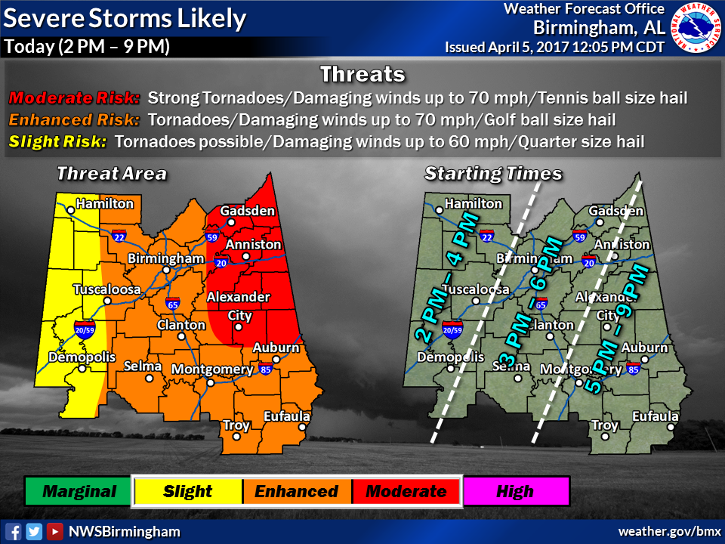
Here is the latest severe weather threat graphic for later on this afternoon through this evening. We have adjusted the severe threat areas based on the latest data coming in. A good portion of Central Alabama remains under a significant threat of severe storms, with all types of severe weather possible. Strong tornadoes remain possible across eastern and northeastern portions of Central Alabama, where the best wind shear remains in place.
Hazardous Weather Outlook
National Weather Service Birmingham AL
238 PM CDT Wed Apr 5 2017
ALZ011>015-017>050-062245-
Marion-Lamar-Fayette-Winston-Walker-Blount-Etowah-Calhoun-Cherokee-
Cleburne-Pickens-Tuscaloosa-Jefferson-Shelby-St. Clair-Talladega-
Clay-Randolph-Sumter-Greene-Hale-Perry-Bibb-Chilton-Coosa-Tallapoosa-
Chambers-Marengo-Dallas-Autauga-Lowndes-Elmore-Montgomery-Macon-
Bullock-Lee-Russell-Pike-Barbour-
238 PM CDT Wed Apr 5 2017
This Hazardous Weather Outlook is for the counties served by the National Weather Service office in Birmingham.
.DAY ONE…Outlook Through Tonight.
Severe thunderstorms will be possible along an approaching cold front across all of Central Alabama with tornadoes, damaging straight line winds, and large hail all possible. The best chances for severe thunderstorms along with strong tornadoes will be along, north, and east of an Oneonta to Lake Martin to Opelika line. The threat will end from west to east after the front moves through and could go to as late as 9 PM across the far eastern counties.
.DAYS TWO THROUGH SEVEN…Thursday through Tuesday.
No hazardous weather is expected at this time.
.SPOTTER INFORMATION STATEMENT…
Activation of storm spotters and emergency management will be necessary through this evening.