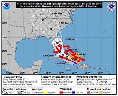
Posted at 8:50 a.m. on 9-8-2017 – According to the National Weather Service, Hurricane Irma is currently heading toward the Bahamas and is moving west-northwest at 16 mph. Maximum sustained winds remain near 150 mph. Irma remains an extremely dangerous Hurricane. Irma is expected to turn to the north this weekend and make landfall near the southern tip of the Florida peninsula and then move northward through the State of Florida and into and through the State of Georgia. Monday into Tuesday the forecast models have Irma moving on a northwesterly track. The current forecast has a large portion of central Alabama including Elmore County possibly receiving winds of 30 to 40 mph and some heavy bands of rain. At this point we anticipate that the core of Irma will be to our east and Elmore County will be on the systems western fringe. There are still many variables that will impact the track of this system. Several changes will likely be made to the forecast. The track could shift west or east, thus changing what impacts we may see drastically from little to no impacts, to strong winds and some heavy rain bands. NWS forecasters and our office will continue to monitor Hurricane Irma and we will provide updates on track, intensity and impacts we may see.
Below you will find the latest Hazardous Weather Outlook issued by the National Weather Service Forecast Office in Birmingham and a couple of graphics from the National Hurricane Center.
We will post significant updates to the forecast to our website at www.elmorecoema.com, Facebook and Twitter.
Hazardous Weather Outlook
National Weather Service Birmingham AL
436 AM CDT Fri Sep 8 2017
ALZ011>015-017>050-091245-
Marion-Lamar-Fayette-Winston-Walker-Blount-Etowah-Calhoun-Cherokee-
Cleburne-Pickens-Tuscaloosa-Jefferson-Shelby-St. Clair-Talladega-
Clay-Randolph-Sumter-Greene-Hale-Perry-Bibb-Chilton-Coosa-Tallapoosa-
Chambers-Marengo-Dallas-Autauga-Lowndes-Elmore-Montgomery-Macon-
Bullock-Lee-Russell-Pike-Barbour-
436 AM CDT Fri Sep 8 2017
This Hazardous Weather Outlook is for the counties served by the
National Weather Service office in Birmingham.
.DAY ONE…Today and Tonight.
No hazardous weather is expected at this time.
.DAYS TWO THROUGH SEVEN…Saturday through Thursday.
As Irma works through the southeast, strong winds will be possible
on Monday and Tuesday across Central Alabama. Winds sustained at 20
to 30 mph with higher gusts are expected. Alot of uncertainty in
regards to timing and strength of the winds as the system moves in
and its exact path. Updates will be made to this outlook if any
changes are significant.
.SPOTTER INFORMATION STATEMENT…
Activation of storm spotters and emergency management is not
expected at this time.