Update on Hurricane Irma
Posted at 3:45 p.m. on 9-8-2017
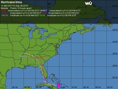
According to the NWS and National Hurricane Center, models have continued with a bit of a westerly shift from this morning’s information. Below is the latest Hazardous Weather Outlook issued by the NWS Forecast Office in Birmingham. According to the NWS, at this point and under the current forecast, Elmore County may experience 20 to 30 mph winds with gusts of 35 to 45 mph and 1.5 to 3 inches of rainfall may be experienced from early Monday through Tuesday. At the least a Wind Advisory will most likely be issued for this timeframe. Again they anticipate some forecast changes to be made. Stay tuned over the weekend as additional changes to the forecast are likely! Also below is the latest graphic from the National Hurricane Center and an additional graphic on the models. They do anticipate changes to the forecast. The NWS will be able to really tighten down the forecast and impacts that we will see after Irma makes the northward turn and after landfall to see how the system reacts after making landfall. We will continue to send out email updates and post the updates to our website, Facebook and Twitter over the weekend as the forecast is updated.
Hazardous Weather Outlook
National Weather Service Birmingham AL
157 PM CDT Fri Sep 8 2017
ALZ011>015-017>050-092200-
Marion-Lamar-Fayette-Winston-Walker-Blount-Etowah-Calhoun-Cherokee-
Cleburne-Pickens-Tuscaloosa-Jefferson-Shelby-St. Clair-Talladega-
Clay-Randolph-Sumter-Greene-Hale-Perry-Bibb-Chilton-Coosa-Tallapoosa-
Chambers-Marengo-Dallas-Autauga-Lowndes-Elmore-Montgomery-Macon-
Bullock-Lee-Russell-Pike-Barbour-
157 PM CDT Fri Sep 8 2017
This Hazardous Weather Outlook is for the counties served by the
National Weather Service office in Birmingham.
.DAY ONE…This Afternoon and Tonight.
No hazardous weather is expected at this time.
.DAYS TWO THROUGH SEVEN…Saturday through Thursday.
Hurricane Irma is expected to move northward through the southeastern
United States next week. For central Alabama, the most active
weather, including highest wind gusts and heaviest rains, is expected
east of I-65 during the Monday to Tuesday time frame. Winds
sustained at 20 to 30 MPH, with gusts around 35 to 45 MPH are
possible. Tropical rains are expected to bring rain totals of 1 to 3
inches. Changes to this forecast are possible and will depend on
Irma`s track in the coming days. A track farther east would mean
lower impacts for central Alabama, while a track farther west would
increase impacts. Continue to monitor the latest forecasts as Irma
nears.
.SPOTTER INFORMATION STATEMENT…
Activation of storm spotters and emergency management is not
expected at this time.
$$