
As of 10:06 A.M. Sunday April 30, 2017
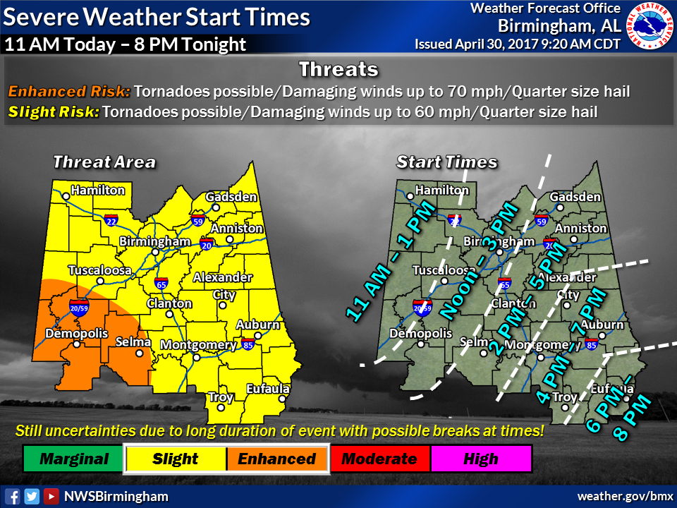
According to the National Weather Service, Weather Forecast Office in Birmingham, AL. Elmore County is still under a Slight Risk for severe weather this afternoon into tomorrow morning. The primary threat being damaging winds up to 60 mph, possible tornadoes, quarter size hail. Timing is from 6:00 P.M. today until 10:00 A.M. tomorrow. Exact timing is still uncertain due to the potential for 2 rounds of storms during this period.
Please find the latest graphics below and the most current Hazardous Weather Outlook (HWO) and
Wind Advisory.

Hazardous Weather Outlook
National Weather Service Birmingham AL
1006 AM CDT Sun Apr 30 2017
ALZ011>015-017>050-011815-
Marion-Lamar-Fayette-Winston-Walker-Blount-Etowah-Calhoun-Cherokee-
Cleburne-Pickens-Tuscaloosa-Jefferson-Shelby-St. Clair-Talladega-
Clay-Randolph-Sumter-Greene-Hale-Perry-Bibb-Chilton-Coosa-Tallapoosa-
Chambers-Marengo-Dallas-Autauga-Lowndes-Elmore-Montgomery-Macon-
Bullock-Lee-Russell-Pike-Barbour-
1006 AM CDT Sun Apr 30 2017
This Hazardous Weather Outlook is for the counties served by the National Weather Service office in Birmingham.
.DAY ONE…Today and Tonight.
There is a threat of severe thunderstorms across all of Central Alabama today through tonight with storms arriving from the west and spreading across the area into this evening. The threats include damaging winds, brief tornadoes, and hail. Some heavy rain at times is possible as well.
Outside of storms, strong gusty gradient winds will be possible today into this evening. Sustained winds will be 15 to 25 mph with gusts to 35 mph or higher. The highest winds will be observed in the higher elevation areas. These gradient winds can be expected through at least 10 PM this evening.
.DAYS TWO THROUGH SEVEN…Monday through Saturday.
Some strong to severe thunderstorms are possible across the far eastern counties through possibly as late as 10 AM.
.SPOTTER INFORMATION STATEMENT…
Activation of storm spotters and emergency management will likely be needed at times today on into Monday morning.
Wind Advisory
URGENT – WEATHER MESSAGE
National Weather Service Birmingham AL
551 AM CDT Sun Apr 30 2017
…Strong Winds Will be Possible at Times Across Central
Alabama…
ALZ011>015-017>050-010300-
/O.CON.KBMX.WI.Y.0005.170430T1300Z-170501T0300Z/
Marion-Lamar-Fayette-Winston-Walker-Blount-Etowah-Calhoun-
Cherokee-Cleburne-Pickens-Tuscaloosa-Jefferson-Shelby-St. Clair-
Talladega-Clay-Randolph-Sumter-Greene-Hale-Perry-Bibb-Chilton-
Coosa-Tallapoosa-Chambers-Marengo-Dallas-Autauga-Lowndes-Elmore-
Montgomery-Macon-Bullock-Lee-Russell-Pike-Barbour-
Including the cities of Hamilton, Sulligent, Vernon, Fayette,
Double Springs, Jasper, Oneonta, Gadsden, Anniston, Centre,
Heflin, Carrollton, Tuscaloosa, Birmingham, Hoover, Columbiana,
Pelham, Alabaster, Pell City, Moody, Talladega, Sylacauga,
Ashland, Roanoke, Livingston, Eutaw, Greensboro, Moundville,
Marion, Centreville, Clanton, Rockford, Alexander City,
Dadeville, Valley, Lanett, Lafayette, Demopolis, Linden, Selma,
Prattville, Fort Deposit, Hayneville, Wetumpka, Tallassee,
Montgomery, Tuskegee, Union Springs, Auburn, Opelika,
Phenix City, Troy, and Eufaula
551 AM CDT Sun Apr 30 2017
…WIND ADVISORY REMAINS IN EFFECT UNTIL 10 PM CDT THIS EVENING…
* TIMING…The strongest winds will be kicking back up after 8
am Sunday morning.
* WINDS…Sustained winds of 15-25 mph, with gusts 35 to 40 from
a southeast to south direction. The highest gusts will be in
the higher elevations.
* IMPACTS…Strong winds could result in large limbs and weak
trees to be blown down. Travel may also be dangerous at times
especially if traveling on an east to west oriented roadway.
PRECAUTIONARY/PREPAREDNESS ACTIONS…
A Wind Advisory means that winds of 25 mph or higher are
expected. Winds this strong can make driving difficult…
especially for high profile vehicles. Use extra caution.