
The NWS-Birmingham changed the forecast for today/tonight. They increased the potential for severe weather in the northwest counties to “Slight” and they moved the “Marginal” potential back to the western edge of Elmore County. Elmore County isn’t in the Marginal zone but we are right on the edge, so we must be aware of the potential in our area.
Also, the timeframe for the line of storms to enter Elmore County will be sometime after 9 p.m. Please refer and make any plans or adjustments for the events tonight.
We hope everyone has a safe and Happy New Year. Don’t Drink and Drive! Stay weather aware tonight!
Hazardous Weather Outlook
National Weather Service Birmingham AL
720 AM CST Mon Dec 31 2018
ALZ011>015-017>050-011630-
Marion-Lamar-Fayette-Winston-Walker-Blount-Etowah-Calhoun-Cherokee-
Cleburne-Pickens-Tuscaloosa-Jefferson-Shelby-St. Clair-Talladega-
Clay-Randolph-Sumter-Greene-Hale-Perry-Bibb-Chilton-Coosa-Tallapoosa-
Chambers-Marengo-Dallas-Autauga-Lowndes-Elmore-Montgomery-Macon-
Bullock-Lee-Russell-Pike-Barbour-
720 AM CST Mon Dec 31 2018
This Hazardous Weather Outlook is for the counties served by the
National Weather Service office in Birmingham.
.DAY ONE…Outlook through Tonight.
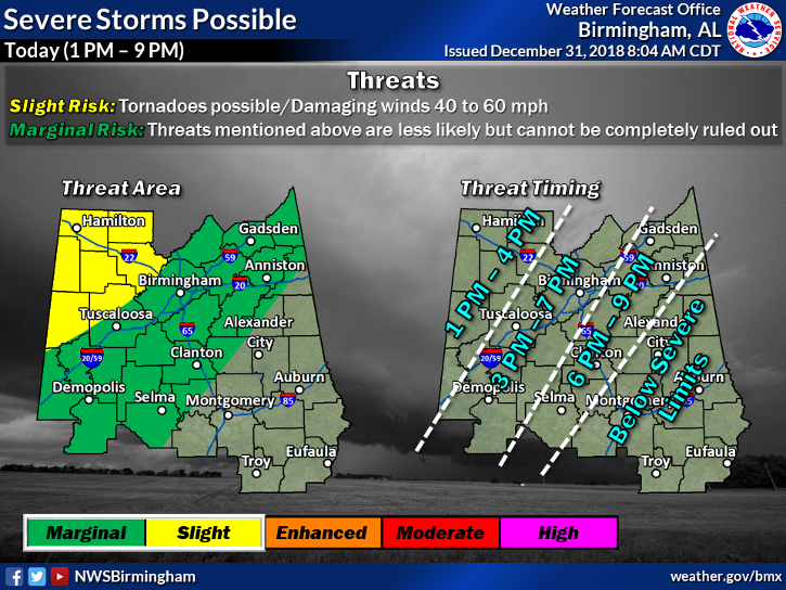
There is a slight chance for severe storms this afternoon after 1 pm
through tonight, around 9 pm. Areas that could be impacted include
areas along and west of a Selma to Clanton to Anniston line. Wind
gusts of 40 to 60 mph are possible with a line of showers and
embedded thunderstorms. In addition to the winds, locally heavy
rainfall is expected as well. A tornado can not be ruled out across
the far northwestern counties, or along and west of a Carrollton to
Cordova line, generally from 1 to 4 pm.
Rises along the rivers will continue and many are near bankfull or
in flood. Please refer to river flood warnings, statements, and
advisories for the latest information.
.DAYS TWO THROUGH SEVEN…Tuesday through Sunday.
Some rivers will continue to experience flooding into next week.
Please refer to river flood warnings, statements, and advisories for
the latest information.
.SPOTTER INFORMATION STATEMENT…
Activation of storm spotters and emergency management may be needed
through this evening.
$$