
03/30/2017 9:15: PM Although there are currently no situations to be reported on in Elmore County, the Elmore County EMA encourages everyone to “Be Ready!”
Active Situation
The information in this post is for Emergency Information only.
NWS Updated Timing for Severe Storms Tonight. 3/30/3017
Update as of 3:35 P.M., Thursday, March 30,2017
From the NWS Birmingham, Alabama
Severe thunderstorms are possible through 11 pm, but will be quite limited. Damaging winds and large hail will be the threat, but a brief tornado can not be ruled out. Stay aware for changes as we approach this event.
.

Updated HWO as of 5:44 P.M. this date:
NWSChat – NOAA’s National Weather Service
Hazardous Weather Outlook
National Weather Service Birmingham AL
544 PM CDT Thu Mar 30 2017

ALZ011>015-017>050-010145-
Marion-Lamar-Fayette-Winston-Walker-Blount-Etowah-Calhoun-Cherokee-
Cleburne-Pickens-Tuscaloosa-Jefferson-Shelby-St. Clair-Talladega-
Clay-Randolph-Sumter-Greene-Hale-Perry-Bibb-Chilton-Coosa-Tallapoosa-
Chambers-Marengo-Dallas-Autauga-Lowndes-Elmore-Montgomery-Macon-
Bullock-Lee-Russell-Pike-Barbour-
544 PM CDT Thu Mar 30 2017

This Hazardous Weather Outlook is for the counties served by the
National Weather Service office in Birmingham.

.DAY ONE...Outlook Through Tonight.

No hazardous weather is expected at this time.

.DAYS TWO THROUGH SEVEN...Friday through Wednesday.

There is a threat of severe thunderstorms, including damaging winds
up to 60 mph, brief tornadoes, and hail up to the size of quarters,
across central Alabama on Monday.

.SPOTTER INFORMATION STATEMENT...

Activation of storm spotters and Emergency Managers may be needed
on Monday.
NWS Update on Possible Severe Weather Now Thru 8 PM Tonight, Mar 30, 2017
03/30/2017 3:32:39 PM According to the latest graphic (below) provided by the National Weather Service, Birmingham, Elmore County remains in the Slight Risk Threat Area. Threats include the possibility of tornados, damaging winds up to 60 mph, and quarter size hail. The timing for the possibility of severe weather impacting Elmore County is now through 8 P.M. tonight. Elmore County EMA will continue to post severe weather updates to their webpage as they become available.

Severe weather threat for Elmore County for today (3-30-17)
Posted at 9:00 a.m. – Elmore County has been placed under a Slight risk for severe weather today by the National Weather Service (NWS). According to the NWS increasing rain chances with a few strong to severe storms during the afternoon will be possible. At this time chances will be even better for strong to severe storms during the evening and overnight hours for Elmore County. The greatest risk for severe weather will be in northwest portions of the state. Also, rain and thunderstorm activity along the coast may prevent severe weather development from occurring in central Alabama. Right now this is still something that that the NWS is watching closely to see what our chances are for the severe weather potential this afternoon, evening and tonight. This update is according to the NWS Weather Forecast Office in Birmingham as of 8:00 a.m. this morning. Below is a graphic provided by the NWS that shows both the potential threat and timing for severe weather for today. Also below is the latest Hazardous Weather Outlook issued by the NWS Weather Forecast Office in Birmingham.
We will continue monitoring the severe weather threat for today and will post updates as needed.

Severe Weather Threat – Thursday afternoon into Thursday night! March 30, 2017
As of 6:00 P.M.
According to the National Weather Service Birmingham, Alabama, there is an increasing rain chance with a few strong to severe storms during the afternoon. Even better chances during the evening. (See the Graphic for the timing and threat concern).
Stay Weather Aware.
HWOBMX
Hazardous Weather Outlook
National Weather Service Birmingham AL
406 PM CDT Wed Mar 29 2017
ALZ011>015-017>050-310015-
Marion-Lamar-Fayette-Winston-Walker-Blount-Etowah-Calhoun-Cherokee-
Cleburne-Pickens-Tuscaloosa-Jefferson-Shelby-St. Clair-Talladega-
Clay-Randolph-Sumter-Greene-Hale-Perry-Bibb-Chilton-Coosa-Tallapoosa-
Chambers-Marengo-Dallas-Autauga-Lowndes-Elmore-Montgomery-Macon-
Bullock-Lee-Russell-Pike-Barbour-
406 PM CDT Wed Mar 29 2017
This Hazardous Weather Outlook is for the counties served by the National Weather Service office in Birmingham.
.DAY ONE…Outlook Through Tonight.
No hazardous weather is expected at this time.
.DAYS TWO THROUGH SEVEN…Thursday through Tuesday.
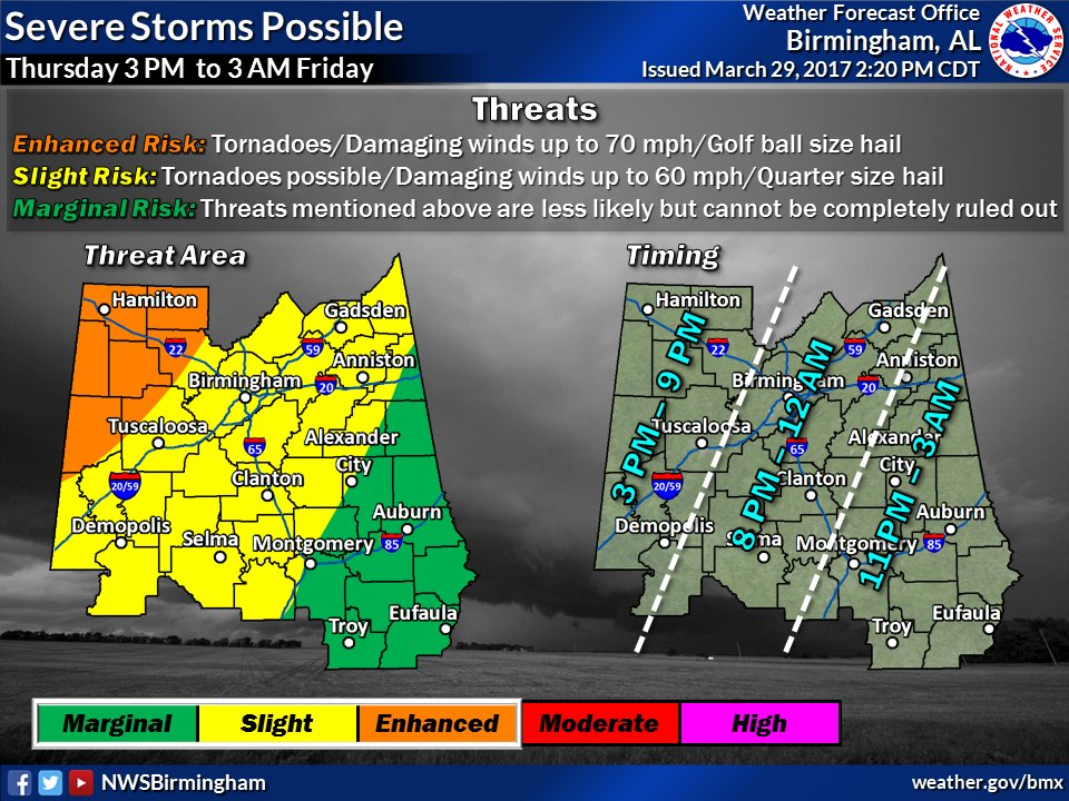
A threat of severe thunderstorms will come Thursday afternoon into Thursday night across all of Central Alabama. Potential threats will include damaging winds up to 70 mph, tornadoes, and hail up to golf ball size. The greatest risk appears to be for areas near Aliceville, Fayette, Vernon, Sulligent, Hamilton, and Double Springs.
A second system will impact the area on Monday as well. Potential threats will include damaging winds up to 60 mph, brief tornadoes, and hail up to the size of quarters.
.SPOTTER INFORMATION STATEMENT…
Activation of storm spotters and Emergency Managers may be needed on Thursday and Monday.
$$
Be Ready Elmore County!
03/28/2017 9:45: PM Although there are currently no reportable situations in Elmore County, the Elmore County EMA encourages everyone to “Be Ready!”
Chance of Severe Weather This Afternoon, 27 Mar, and Again on Thursday, 30 Mar, 2017
03/27/2017 12:12:10 PM According to the National Weather Service there is a possibility strong to severe thunderstorms will develop today to our northwest, then slide through our area during the afternoon hours. At this time, the best chance for development of severe weather is in the northwestern sections of Central Alabama. Elmore County is under a marginal risk for severe weather this afternoon and later tonight. (See the graphics below.)
There is also a threat for strong to severe thunderstorms Thursday afternoon into Thursday night, Mar 30th, 2017. All modes of severe weather, including tornadoes, will be possible with this storm system. Please stay alert for updates to this forecast as Thursday draws closer.
Elmore County EMA will continue to monitor these storm systems and will update our webpage as the NWS releases new forecast data.


Be Ready, Elmore County!
03/27/2017 8:30: AM Although there are currently no reportable situations in Elmore County, the Elmore County EMA encourages everyone to “Be Ready!”
Update #3: Three Rounds of Strong to Severe Thunderstorms Possible Mar 25th, 27th, and 30th. Stay Weather Aware!!
As of 9:15 P.M. March 25, 2017
Round 1 Complete!
Graphic for Sunday March 26,2017 and HWO for March 27 and March 30th

HWOBMX
Hazardous Weather Outlook
National Weather Service Birmingham AL
514 PM CDT Sat Mar 25 2017
ALZ011>015-017>050-270115-
Marion-Lamar-Fayette-Winston-Walker-Blount-Etowah-Calhoun-Cherokee-
Cleburne-Pickens-Tuscaloosa-Jefferson-Shelby-St. Clair-Talladega-
Clay-Randolph-Sumter-Greene-Hale-Perry-Bibb-Chilton-Coosa-Tallapoosa-
Chambers-Marengo-Dallas-Autauga-Lowndes-Elmore-Montgomery-Macon-
Bullock-Lee-Russell-Pike-Barbour-
514 PM CDT Sat Mar 25 2017
This Hazardous Weather Outlook is for the counties served by the National Weather Service office in Birmingham.
.DAY ONE…Outlook Through Tonight.
No hazardous weather is expected through tonight.
.DAYS TWO THROUGH SEVEN…Sunday through Friday.
Round 2 – Severe storms are possible Monday afternoon and evening. The best chances for severe will be across the western half, generally west of Interstate 65. The main threats will be damaging straight line winds and large hail.
Round 3 – Another round of severe storms will be possible on Thursday across Central Alabama. The main threats will be damaging straight line winds and large hail.
.SPOTTER INFORMATION STATEMENT…
Activation of storm spotters and emergency management may be needed today as well as Monday and Thursday.
$$
Update for today’s severe weather potential in Elmore County (Saturday, March 25, 2017)
There has been an update on today’s weather forecast issued by the National Weather Service (NWS).
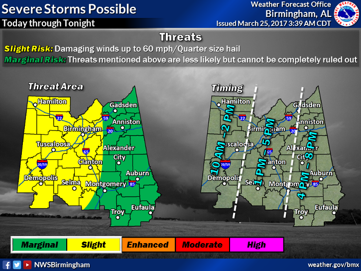
A line of strong to severe storms will be possible from around 10 AM to 8 PM in association with an upper level storm system. While this activity will be possible across most of Central Alabama, the best chances for severe will be across the western half. The main threat will be damaging straight line winds and hail. The best timing for the strong to severe storms will be from 10 to 2 in the west, 1 to 5 in Central an 4 to 8 in the east.
As you can see there has been a change in the severe threats. Not only the chance of damaging straight line winds up to 60 mph, but the addition of hail is now possible. Also the timing has changed as indicated on the right side of the graphic below. The main threat area still remains west of Interstate 65.
As always Elmore County EMA will be monitoring the situation and updating our website at www.elmorecoema.com. If you have questions please do not hesitate to call us. We will send further information as made available about the severe weather potential for Monday the 27th and Thursday the 30th.
Please find the most up-to-date graphic and Hazardous Weather Outlook (HWO) below:
National Weather Service (NWS) HWO:
Hazardous Weather Outlook
National Weather Service Birmingham AL
759 AM CDT Sat Mar 25 2017
ALZ011>015-017>050-261600-
Marion-Lamar-Fayette-Winston-Walker-Blount-Etowah-Calhoun-Cherokee-
Cleburne-Pickens-Tuscaloosa-Jefferson-Shelby-St. Clair-Talladega-
Clay-Randolph-Sumter-Greene-Hale-Perry-Bibb-Chilton-Coosa-Tallapoosa-
Chambers-Marengo-Dallas-Autauga-Lowndes-Elmore-Montgomery-Macon-
Bullock-Lee-Russell-Pike-Barbour-
759 AM CDT Sat Mar 25 2017
This Hazardous Weather Outlook is for the counties served by the
National Weather Service office in Birmingham.
.DAY ONE…Outlook Through Tonight.
Severe storms will be possible today from 10 AM until 8 PM. Severe
storms are possible across all of central Alabama, but the best
chance for severe weather will be across the western half, generally
west of Interstate 65. The main threats will be damaging straight
line winds and large hail.
.DAYS TWO THROUGH SEVEN…Sunday through Friday.
Severe storms are possible Monday afternoon and evening. Again,
severe storms will be possible across all of Central Alabama.
However, the best chances for severe will be across the western half,
generally west of Interstate 65. The main threats will be damaging
straight line winds and large hail.
Another round of severe storms will be possible on Thursday across
Central Alabama. The main threats will be damaging straight line
winds and large hail.
.SPOTTER INFORMATION STATEMENT…
Activation of storm spotters and emergency management may be needed
today as well as Monday and Thursday.
$$