
05/30/2017 – 10:30 P.M. There are currently no emergency situations to be reported on in Elmore County. Elmore County EMA encourages everyone to “Be Ready!”
Active Situation
The information in this post is for Emergency Information only.
The Flash Flood Watch has been cancelled for Elmore County…
Posted at 2:50 p.m., 5/23/2017 – The National Weather Service has cancelled the Flash Flood Watch for Elmore County.
A Flash Flood Watch is in effect beginning at 1:00 p.m. for Elmore County lasting through Tuesday evening….
The National Weather Service (NWS) issued a Flash Flood Watch that goes into effect today (May 22, 2017) at 1:00 p.m. for Elmore County until tomorrow (Tuesday) evening. A Flash Flood Watch means that conditions may develop that lead to flash flooding. Flash flooding is a very dangerous situation.
Remember… “Turn Around, Don’t Drown”

Be Ready, Elmore County!!!
05/21/2017 – 2:00 P.M. There are currently no emergency situations to be reported on in Elmore County. Elmore County EMA encourages everyone to “Be Ready!”
Flash Flood Warning Extended until 4:30 a.m.
Update issued by the National Weather Service, Weather Forecast Office in Birmingham, AL
BULLETIN – Flash Flood Warning
National Weather Service Birmingham AL
1035 PM CDT SAT MAY 20 2017
The National Weather Service in Birmingham has issued a
* Flash Flood Warning for…
Central Autauga County in Alabama…
Elmore County in east central Alabama…
Lowndes County in south central Alabama…
Southeastern Dallas County in south central Alabama…
Montgomery County in south central Alabama…
* Until 430 AM CDT
* At 1033 PM CDT, broadcast media reported flash flooding across the
warned area. Three to seven inches of rain have fallen.
Flash flooding is already occurring.
* Some locations that will experience flooding include…
Montgomery, Prattville, Millbrook, Wetumpka, Tallassee, Fort
Deposit, Mosses, Hayneville, Meadville, Pike Road, Elmore, Coosada,
Deatsville, Eclectic, Autaugaville, White Hall, Gordonville,
Lowndesboro, Benton and Santuck.
Additional rainfall amounts of one to two inches are possible in the
warned area.
PRECAUTIONARY/PREPAREDNESS ACTIONS…
Turn around, don’t drown when encountering flooded roads. Most flood
deaths occur in vehicles.
Be especially cautious at night when it is harder to recognize the dangers of flooding.
ELMORE COUNTY IS UNDER A FLASH FLOOD WARNING UNTIL 12 MIDNIGHT
From the National Weather Service, Weather Forecast Office in Birmingham, AL
Flash Flood Warning
National Weather Service Birmingham AL
900 PM CDT SAT MAY 20 2017
The National Weather Service in Birmingham has issued a
* Flash Flood Warning for…
Elmore County in east central Alabama…
Northeastern Montgomery County in south central Alabama…
* Until midnight CDT
* At 859 PM CDT, Doppler radar indicated thunderstorms producing
heavy rain across the warned area. Up to three inches of rain have
already fallen. Flash flooding is expected to begin shortly.
* Some locations that will experience flooding include…
Montgomery, Wetumpka, Tallassee, Deatsville, Eclectic, Santuck,
Auburn University In Montgomery, Titus, Emerald Mountain, Ten Cedar
Estates, Waugh, Dexter, Lagoon Park, Martin Lake At Kowaliga, Weoka
Mills, Jordan Lake, Eastdale Mall, Mount Meigs, Blue Ridge and
Pinedale.
PRECAUTIONARY/PREPAREDNESS ACTIONS…
Turn around, don’t drown when encountering flooded roads. Most flood
deaths occur in vehicles.
Be especially cautious at night when it is harder to recognize the
dangers of flooding.
Be Ready, Elmore County!!!
05/2/2017 – 10:25 P.M. There are currently no emergency situations to be reported on in Elmore County. Elmore County EMA encourages everyone to “Be Ready!”
Tornado Watch cancelled for Elmore County at 6:20 p.m.
Posted at 6:22 p.m. 4/30/17 – The NWS allowed the Tornado Watch for Elmore County to expire at 6:20 p.m. this evening. The severe weather threat has diminished according to the NWS. Showers and some thunderstorms will remain in the forecast through the mid-morning hours tomorrow, however there is not a severe weather threat associated with this activity.
Elmore County under a Tornado Watch until 7:00 P.M.
WATCH COUNTY NOTIFICATION FOR WATCHES 182/183
NATIONAL WEATHER SERVICE BIRMINGHAM AL
237 PM CDT SUN APR 30 2017

ALC057-063-065-093-125-127-133-302045-
/O.CAN.KBMX.TO.A.0182.000000T0000Z-170501T0000Z/

THE NATIONAL WEATHER SERVICE HAS CANCELLED TORNADO WATCH 182 FOR
THE FOLLOWING AREAS

IN ALABAMA THIS CANCELS 7 COUNTIES

IN CENTRAL ALABAMA
WALKER

IN NORTHWEST ALABAMA
MARION                WINSTON

IN WEST CENTRAL ALABAMA
FAYETTE               GREENE                HALE
TUSCALOOSA

THIS INCLUDES THE CITIES OF EUTAW, FAYETTE, GREENSBORO,
HALEYVILLE, HAMILTON, JASPER, MOUNDVILLE, AND TUSCALOOSA.
ALC001-007-009-021-047-073-091-105-117-010000-
/O.CON.KBMX.TO.A.0182.000000T0000Z-170501T0000Z/

TORNADO WATCH 182 REMAINS VALID UNTIL 7 PM CDT THIS EVENING FOR
THE FOLLOWING AREAS

IN ALABAMA THIS WATCH INCLUDES 9 COUNTIES

IN CENTRAL ALABAMA
AUTAUGA               BIBB                  BLOUNT
CHILTON               DALLAS                JEFFERSON
PERRY                 SHELBY

IN WEST CENTRAL ALABAMA
MARENGO

THIS INCLUDES THE CITIES OF ALABASTER, BIRMINGHAM, BRENT,
CENTREVILLE, CLANTON, COLUMBIANA, DEMOPOLIS, HOOVER, LINDEN,
MARION, ONEONTA, PELHAM, PRATTVILLE, SELMA, AND UNIONTOWN.

ALC015-017-019-027-029-037-051-055-111-115-121-123-010000-
/O.CON.KBMX.TO.A.0183.000000T0000Z-170501T0000Z/

TORNADO WATCH 183 REMAINS VALID UNTIL 7 PM CDT THIS EVENING FOR
THE FOLLOWING AREAS

IN ALABAMA THIS WATCH INCLUDES 12 COUNTIES

IN CENTRAL ALABAMA
COOSA                 ELMORE                ST. CLAIR
TALLADEGA

IN EAST CENTRAL ALABAMA
CALHOUN               CHAMBERS              CLAY
CLEBURNE              RANDOLPH              TALLAPOOSA

IN NORTHEAST ALABAMA
CHEROKEE              ETOWAH

THIS INCLUDES THE CITIES OF ALEXANDER CITY, ANNISTON, ASHLAND,
CENTRE, GADSDEN, HEFLIN, JACKSONVILLE, LANETT, LINEVILLE,
MILLBROOK, MOODY, PELL CITY, ROANOKE, ROCKFORD, SYLACAUGA,
TALLADEGA, VALLEY, AND WETUMPKA.
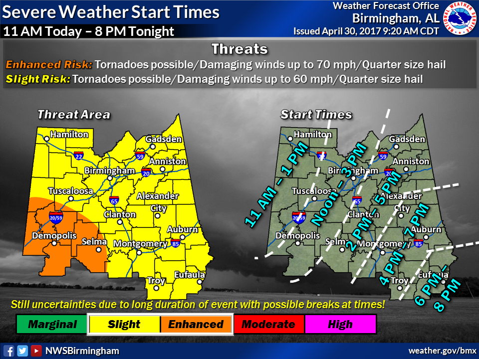
UPDATE 2: Severe Weather Threat for Sunday Night into Monday Morning 4-30 into 5-1
As of 10:06 A.M. Sunday April 30, 2017
According to the National Weather Service, Weather Forecast Office in Birmingham, AL. Elmore County is still under a Slight Risk for severe weather this afternoon into tomorrow morning. The primary threat being damaging winds up to 60 mph, possible tornadoes, quarter size hail. Timing is from 6:00 P.M. today until 10:00 A.M. tomorrow. Exact timing is still uncertain due to the potential for 2 rounds of storms during this period.
Please find the latest graphics below and the most current Hazardous Weather Outlook (HWO) and
Wind Advisory.

Hazardous Weather Outlook
National Weather Service Birmingham AL
1006 AM CDT Sun Apr 30 2017
ALZ011>015-017>050-011815-
Marion-Lamar-Fayette-Winston-Walker-Blount-Etowah-Calhoun-Cherokee-
Cleburne-Pickens-Tuscaloosa-Jefferson-Shelby-St. Clair-Talladega-
Clay-Randolph-Sumter-Greene-Hale-Perry-Bibb-Chilton-Coosa-Tallapoosa-
Chambers-Marengo-Dallas-Autauga-Lowndes-Elmore-Montgomery-Macon-
Bullock-Lee-Russell-Pike-Barbour-
1006 AM CDT Sun Apr 30 2017
This Hazardous Weather Outlook is for the counties served by the National Weather Service office in Birmingham.
.DAY ONE…Today and Tonight.
There is a threat of severe thunderstorms across all of Central Alabama today through tonight with storms arriving from the west and spreading across the area into this evening. The threats include damaging winds, brief tornadoes, and hail. Some heavy rain at times is possible as well.
Outside of storms, strong gusty gradient winds will be possible today into this evening. Sustained winds will be 15 to 25 mph with gusts to 35 mph or higher. The highest winds will be observed in the higher elevation areas. These gradient winds can be expected through at least 10 PM this evening.
.DAYS TWO THROUGH SEVEN…Monday through Saturday.
Some strong to severe thunderstorms are possible across the far eastern counties through possibly as late as 10 AM.
.SPOTTER INFORMATION STATEMENT…
Activation of storm spotters and emergency management will likely be needed at times today on into Monday morning.
Wind Advisory
URGENT – WEATHER MESSAGE
National Weather Service Birmingham AL
551 AM CDT Sun Apr 30 2017
…Strong Winds Will be Possible at Times Across Central
Alabama…
ALZ011>015-017>050-010300-
/O.CON.KBMX.WI.Y.0005.170430T1300Z-170501T0300Z/
Marion-Lamar-Fayette-Winston-Walker-Blount-Etowah-Calhoun-
Cherokee-Cleburne-Pickens-Tuscaloosa-Jefferson-Shelby-St. Clair-
Talladega-Clay-Randolph-Sumter-Greene-Hale-Perry-Bibb-Chilton-
Coosa-Tallapoosa-Chambers-Marengo-Dallas-Autauga-Lowndes-Elmore-
Montgomery-Macon-Bullock-Lee-Russell-Pike-Barbour-
Including the cities of Hamilton, Sulligent, Vernon, Fayette,
Double Springs, Jasper, Oneonta, Gadsden, Anniston, Centre,
Heflin, Carrollton, Tuscaloosa, Birmingham, Hoover, Columbiana,
Pelham, Alabaster, Pell City, Moody, Talladega, Sylacauga,
Ashland, Roanoke, Livingston, Eutaw, Greensboro, Moundville,
Marion, Centreville, Clanton, Rockford, Alexander City,
Dadeville, Valley, Lanett, Lafayette, Demopolis, Linden, Selma,
Prattville, Fort Deposit, Hayneville, Wetumpka, Tallassee,
Montgomery, Tuskegee, Union Springs, Auburn, Opelika,
Phenix City, Troy, and Eufaula
551 AM CDT Sun Apr 30 2017
…WIND ADVISORY REMAINS IN EFFECT UNTIL 10 PM CDT THIS EVENING…
* TIMING…The strongest winds will be kicking back up after 8
am Sunday morning.
* WINDS…Sustained winds of 15-25 mph, with gusts 35 to 40 from
a southeast to south direction. The highest gusts will be in
the higher elevations.
* IMPACTS…Strong winds could result in large limbs and weak
trees to be blown down. Travel may also be dangerous at times
especially if traveling on an east to west oriented roadway.
PRECAUTIONARY/PREPAREDNESS ACTIONS…
A Wind Advisory means that winds of 25 mph or higher are
expected. Winds this strong can make driving difficult…
especially for high profile vehicles. Use extra caution.