Update on Hurricane Irma (9-9-2017 at 8:30 a.m.)

Update on Hurricane Irma

Posted at 8:30 a.m. on 9-9-2017

Yesterday evening at approximately 6:30 p.m. Governor Ivey issued a State of Emergency ahead of Hurricane Irma.

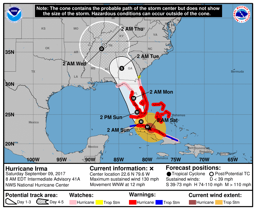
According to the NWS a few minor changes have been made from yesterday evening’s forecast information. Below is the latest Hazardous Weather Outlook issued by the NWS Forecast Office in Birmingham. According to the NWS, at this point and under the current forecast, Elmore County may experience 20 to 30 mph winds with gusts of 40 to 50 mph and 1.5 to 3 inches of rainfall may be experienced from early Monday through early Tuesday. At the least a Wind Advisory will likely be issued for this timeframe. This will result in downed trees and some power outages are likely. Also below is the latest graphic from the National Hurricane Center and an additional graphic from the NWS Forecast Office in Birmingham on the areas that will see impacts in the State and what impacts we are likely to see. Some changes to the forecast are still likely. We will continue to send out email updates and post the updates to our website, Facebook and Twitter over the weekend as the forecast is updated.

Hazardous Weather Outlook
National Weather Service Birmingham AL
525 AM CDT Sat Sep 9 2017

ALZ011>015-017>050-101330-
Marion-Lamar-Fayette-Winston-Walker-Blount-Etowah-Calhoun-Cherokee-
Cleburne-Pickens-Tuscaloosa-Jefferson-Shelby-St. Clair-Talladega-
Clay-Randolph-Sumter-Greene-Hale-Perry-Bibb-Chilton-Coosa-Tallapoosa-
Chambers-Marengo-Dallas-Autauga-Lowndes-Elmore-Montgomery-Macon-
Bullock-Lee-Russell-Pike-Barbour-
525 AM CDT Sat Sep 9 2017

This Hazardous Weather Outlook is for the counties served by the
National Weather Service office in Birmingham.

.DAY ONE…Today and Tonight.

No hazardous weather is expected at this time.

.DAYS TWO THROUGH SEVEN…Sunday through Friday.

Hurricane Irma is expected to move northward through the Southeast
United States early next week. For central Alabama, the most active
weather, including highest wind gusts and heaviest rainfall, is
expected along and east of I-65 during the Monday to Tuesday time
frame. Winds sustained at 20 to 30 MPH, with gusts of 40 to 50 mph,
are likely. This could result in downed trees and some power outages.
Tropical rains are expected to bring rainfall totals of 1 to 3 inches.
Changes to this forecast are possible and will depend on Irma`s track
in the coming days. A track farther east would mean lower impacts
for central Alabama, while a track farther west would increase
impacts. Continue to monitor the latest forecasts as Irma nears.

.SPOTTER INFORMATION STATEMENT…

Activation of storm spotters and emergency management is not
expected at this time.

$$


Update on Hurricane Irma (9-8-2017 at 3:45 p.m.)

Update on Hurricane Irma

Posted at 3:45 p.m. on 9-8-2017

According to the NWS and National Hurricane Center, models have continued with a bit of a westerly shift from this morning’s information. Below is the latest Hazardous Weather Outlook issued by the NWS Forecast Office in Birmingham. According to the NWS, at this point and under the current forecast, Elmore County may experience 20 to 30 mph winds with gusts of 35 to 45 mph and 1.5 to 3 inches of rainfall may be experienced from early Monday through Tuesday. At the least a Wind Advisory will most likely be issued for this timeframe. Again they anticipate some forecast changes to be made. Stay tuned over the weekend as additional changes to the forecast are likely! Also below is the latest graphic from the National Hurricane Center and an additional graphic on the models. They do anticipate changes to the forecast. The NWS will be able to really tighten down the forecast and impacts that we will see after Irma makes the northward turn and after landfall to see how the system reacts after making landfall. We will continue to send out email updates and post the updates to our website, Facebook and Twitter over the weekend as the forecast is updated.

Hazardous Weather Outlook
National Weather Service Birmingham AL
157 PM CDT Fri Sep 8 2017

ALZ011>015-017>050-092200-
Marion-Lamar-Fayette-Winston-Walker-Blount-Etowah-Calhoun-Cherokee-
Cleburne-Pickens-Tuscaloosa-Jefferson-Shelby-St. Clair-Talladega-
Clay-Randolph-Sumter-Greene-Hale-Perry-Bibb-Chilton-Coosa-Tallapoosa-
Chambers-Marengo-Dallas-Autauga-Lowndes-Elmore-Montgomery-Macon-
Bullock-Lee-Russell-Pike-Barbour-
157 PM CDT Fri Sep 8 2017

This Hazardous Weather Outlook is for the counties served by the
National Weather Service office in Birmingham.

.DAY ONE…This Afternoon and Tonight.

No hazardous weather is expected at this time.

.DAYS TWO THROUGH SEVEN…Saturday through Thursday.

Hurricane Irma is expected to move northward through the southeastern
United States next week. For central Alabama, the most active
weather, including highest wind gusts and heaviest rains, is expected
east of I-65 during the Monday to Tuesday time frame. Winds
sustained at 20 to 30 MPH, with gusts around 35 to 45 MPH are
possible. Tropical rains are expected to bring rain totals of 1 to 3
inches. Changes to this forecast are possible and will depend on
Irma`s track in the coming days. A track farther east would mean
lower impacts for central Alabama, while a track farther west would
increase impacts. Continue to monitor the latest forecasts as Irma
nears.

.SPOTTER INFORMATION STATEMENT…

Activation of storm spotters and emergency management is not
expected at this time.

$$


Update on impacts of Hurricane Irma (9-8-2017)

Posted at 8:50 a.m. on 9-8-2017 – According to the National Weather Service, Hurricane Irma is currently heading toward the Bahamas and is moving west-northwest at 16 mph. Maximum sustained winds remain near 150 mph. Irma remains an extremely dangerous Hurricane. Irma is expected to turn to the north this weekend and make landfall near the southern tip of the Florida peninsula and then move northward through the State of Florida and into and through the State of Georgia. Monday into Tuesday the forecast models have Irma moving on a northwesterly track. The current forecast has a large portion of central Alabama including Elmore County possibly receiving winds of 30 to 40 mph and some heavy bands of rain. At this point we anticipate that the core of Irma will be to our east and Elmore County will be on the systems western fringe. There are still many variables that will impact the track of this system. Several changes will likely be made to the forecast. The track could shift west or east, thus changing what impacts we may see drastically from little to no impacts, to strong winds and some heavy rain bands. NWS forecasters and our office will continue to monitor Hurricane Irma and we will provide updates on track, intensity and impacts we may see.

Below you will find the latest Hazardous Weather Outlook issued by the National Weather Service Forecast Office in Birmingham and a couple of graphics from the National Hurricane Center.

We will post significant updates to the forecast to our website at www.elmorecoema.com, Facebook and Twitter.

Hazardous Weather Outlook
National Weather Service Birmingham AL
436 AM CDT Fri Sep 8 2017

ALZ011>015-017>050-091245-
Marion-Lamar-Fayette-Winston-Walker-Blount-Etowah-Calhoun-Cherokee-
Cleburne-Pickens-Tuscaloosa-Jefferson-Shelby-St. Clair-Talladega-
Clay-Randolph-Sumter-Greene-Hale-Perry-Bibb-Chilton-Coosa-Tallapoosa-
Chambers-Marengo-Dallas-Autauga-Lowndes-Elmore-Montgomery-Macon-
Bullock-Lee-Russell-Pike-Barbour-
436 AM CDT Fri Sep 8 2017

This Hazardous Weather Outlook is for the counties served by the
National Weather Service office in Birmingham.

.DAY ONE…Today and Tonight.

No hazardous weather is expected at this time.

.DAYS TWO THROUGH SEVEN…Saturday through Thursday.

As Irma works through the southeast, strong winds will be possible
on Monday and Tuesday across Central Alabama. Winds sustained at 20
to 30 mph with higher gusts are expected. Alot of uncertainty in
regards to timing and strength of the winds as the system moves in
and its exact path. Updates will be made to this outlook if any
changes are significant.

.SPOTTER INFORMATION STATEMENT…

Activation of storm spotters and emergency management is not
expected at this time.

Elmore County could feel some impacts of Irma as the track late in the weekend shifts some to the west……..

Posted at 11:00 p.m. on 9-7-2017 – According to the National Weather Service (NWS), Elmore County could feel some impacts of Irma as the track late in the weekend shifts some to the west. The current forecast is for Hurricane Irma to make landfall at the southern tip of Florida Saturday night or very early Sunday morning. The current track carries the the storm into the State of Georgia through the day on Sunday and then possibly turning westerly and entering the east-central or north-east portion of the State of Alabama. As the system moves further north it will be decreasing in intensity. We will have a full updated forecast issued by the NWS tomorrow morning (9-8-17) and will post all updated information as the forecast is updated. We will continue to monitor this situation very closely and posts updates as needed. Stay tuned to the forecast and stay prepared!

Hurricane Irma update (9-7-2017 at 9:00 a.m.)…….

Posted at 9:00 a.m. on 9-7-2017 – According to the National Hurricane Center, Hurricane Irma is expected to pass north of Hispaniola today and be near the Caicos and Bahamas, moving west-northwest at 17 mph. Maximum sustained winds remain near 180 mph. Irma remains an extremely dangerous Category 5 Hurricane. Irma is expected to turn more northward Saturday over Florida. On this track, Hurricane Irma’s high impact weather looks to be east of our area this weekend and into early next week. According to the National Weather Service, the cool air that we are experiencing this morning is part of the system and trough that is going to cause the steering of Irma to the north, north east. Should the forecast track remain the same we will likely begin to see some breezy conditions late Sunday into Monday and they may linger as long as Wednesday.

Below is part of the latest forecast discussion posted by National Hurricane Center; a graphic from the National Hurricane Center showing the timing, intensity and the cone of uncertainty of Irma’s track; and a couple of graphics showing the models of many of the potential storm tracks.

This is a very dangerous system and will have catastrophic effects on the areas that it impacts. Use this time now to contact family and friends that you may have in the forecasted path to encourage them to put their Emergency Plans into action now.

Residents of Elmore County, this is a great time to review your Emergency Plans now! Should this system make any last minute drastic changes or should the next system impact our area, we need to be ready to put those emergency plans into action.


DISCUSSION AND 48-HOUR OUTLOOK

——————————

At 800 AM AST (1200 UTC), the eye of Hurricane Irma was located near latitude 20.1 North, longitude 69.0 West. Irma is moving toward the west-northwest near 17 mph (28 km/h), and this general motion is expected to continue with some decrease in forward speed for the next couple of days.  On the forecast track, the eye of Irma should continue to move just north of the coast of Hispaniola today, be near the Turks and Caicos and southeastern Bahamas by this evening, and then be near the Central Bahamas by Friday. Maximum sustained winds remain near 180 mph (285 km/h) with higher gusts.  Irma is a category 5 hurricane on the Saffir-Simpson Hurricane Wind Scale.  Some fluctuations in intensity are likely during the next day or two, but Irma is forecast to remain a powerful category 4 or 5 hurricane during the next couple of days. Hurricane-force winds extend outward up to 50 miles (85 km) from the center and tropical-storm-force winds extend outward up to 185 miles (295 km). The latest minimum central pressure just reported by an Air Force Hurricane Hunter plane is 921 mb (27.20 inches).


Elmore County under a Wind Advisory

The National Weather Service / Weather Forecast Office in Birmingham has placed Elmore County under a Wind Advisory until 6:00 P.M. tonight. 
A Wind Advisory means that wind gusts of 35 MPH are expected. Winds this strong can make driving difficult...especially for high profile vehicles. Use extra caution.

Hazardous Weather Outlook
National Weather Service Birmingham AL
404 AM CDT Fri Sep 1 2017

ALZ011>015-017>050-021215-
Marion-Lamar-Fayette-Winston-Walker-Blount-Etowah-Calhoun-Cherokee-
Cleburne-Pickens-Tuscaloosa-Jefferson-Shelby-St. Clair-Talladega-
Clay-Randolph-Sumter-Greene-Hale-Perry-Bibb-Chilton-Coosa-Tallapoosa-
Chambers-Marengo-Dallas-Autauga-Lowndes-Elmore-Montgomery-Macon-
Bullock-Lee-Russell-Pike-Barbour-
404 AM CDT Fri Sep 1 2017

This Hazardous Weather Outlook is for the counties served by the
National Weather Service office in Birmingham.

.DAY ONE...Outlook through Tonight.

Windy conditions will be present overnight with sustained winds of
15 to 25 MPH along with gusts up to 35 MPH possible. The area of
highest winds will be generally along and northwest of the Interstate
85 corridor.

.DAYS TWO THROUGH SEVEN...Saturday through Thursday.

No hazardous weather is anticipated at this time.

.SPOTTER INFORMATION STATEMENT...

Activation of storm spotters and emergency management is not
expected at this time.

$$

Wind Advisory

URGENT - WEATHER MESSAGE
National Weather Service Birmingham AL
544 AM CDT Fri Sep 1 2017

...Gusty winds possible across much of Central Alabama today...

ALZ011>015-017>045-047-012300-
/O.CON.KBMX.WI.Y.0007.000000T0000Z-170901T2300Z/
Marion-Lamar-Fayette-Winston-Walker-Blount-Etowah-Calhoun-
Cherokee-Cleburne-Pickens-Tuscaloosa-Jefferson-Shelby-St. Clair-
Talladega-Clay-Randolph-Sumter-Greene-Hale-Perry-Bibb-Chilton-
Coosa-Tallapoosa-Chambers-Marengo-Dallas-Autauga-Lowndes-Elmore-
Montgomery-Macon-Lee-
Including the cities of Hamilton, Sulligent, Vernon, Fayette,
Double Springs, Jasper, Oneonta, Gadsden, Anniston, Centre,
Heflin, Carrollton, Tuscaloosa, Birmingham, Hoover, Columbiana,
Pelham, Alabaster, Pell City, Moody, Talladega, Sylacauga,
Ashland, Roanoke, Livingston, Eutaw, Greensboro, Moundville,
Marion, Centreville, Clanton, Rockford, Alexander City,
Dadeville, Valley, Lanett, Lafayette, Demopolis, Linden, Selma,
Prattville, Fort Deposit, Hayneville, Wetumpka, Tallassee,
Montgomery, Tuskegee, Auburn, and Opelika
544 AM CDT Fri Sep 1 2017

...WIND ADVISORY REMAINS IN EFFECT UNTIL 6 PM CDT THIS EVENING...

* TIMING...will continue through Friday afternoon.

* WINDS...will be between 15 and 25 MPH with gusts up to 35 MPH.

* IMPACTS...of the strong winds may break small limbs and cause
  hazardous driving conditions.

PRECAUTIONARY/PREPAREDNESS ACTIONS...

A Wind Advisory means that wind gusts of 35 MPH are expected.
Winds this strong can make driving difficult...especially for
high profile vehicles. Use extra caution.

&&

Elmore County under a Marginal Risk for Severe Weather, Thursday, August 31, 2017

According to the National Weather Service in Birmingham, AL, Elmore County is under a marginal risk for Severe Weather on Thursday, August 31, 2017.

There is a very low risk for brief, weak tornadoes that will continue through the day on Thursday, mainly between 11 AM and midnight. Areas along and north of a line from Demopolis to Calera to Anniston are under a slight risk, while areas further south are in a marginal risk. Below is a graphic form the Weather Forecast Office in Birmingham and the Hazardous Weather Outlook (HWO).


(HWO)

Hazardous Weather Outlook

Hazardous Weather Outlook
National Weather Service Birmingham AL
1101 AM CDT Thu Aug 31 2017

ALZ011>015-017>050-011915-
Marion-Lamar-Fayette-Winston-Walker-Blount-Etowah-Calhoun-Cherokee-
Cleburne-Pickens-Tuscaloosa-Jefferson-Shelby-St. Clair-Talladega-
Clay-Randolph-Sumter-Greene-Hale-Perry-Bibb-Chilton-Coosa-Tallapoosa-
Chambers-Marengo-Dallas-Autauga-Lowndes-Elmore-Montgomery-Macon-
Bullock-Lee-Russell-Pike-Barbour-
1101 AM CDT Thu Aug 31 2017

This Hazardous Weather Outlook is for the counties served by the
National Weather Service office in Birmingham.

.DAY ONE...Outlook through Tonight.

The remnants of Harvey will approach Alabama and is expected to
bring a threat for brief tornadoes to the forecast area. The threat
could continue until 10 PM. The best chance for brief tornadoes
should generally be along and northwest of a line from Selma to
Clanton to Wedowee, though a brief tornado cannot be ruled out
farther south and east.

.DAYS TWO THROUGH SEVEN...Friday through Wednesday.

No hazardous weather is expected at this time.

.SPOTTER INFORMATION STATEMENT...

Activation of storm spotters and emergency management may be needed
through tonight.

$$