As of 9:15 AM, December 7, 2017
Hazardous Weather Outlook
Hazardous Weather Outlook
National Weather Service Birmingham AL
504 AM CST Thu Dec 7 2017
ALZ011>015-017>050-081415-
Marion-Lamar-Fayette-Winston-Walker-Blount-Etowah-Calhoun-Cherokee-
Cleburne-Pickens-Tuscaloosa-Jefferson-Shelby-St. Clair-Talladega-
Clay-Randolph-Sumter-Greene-Hale-Perry-Bibb-Chilton-Coosa-Tallapoosa-
Chambers-Marengo-Dallas-Autauga-Lowndes-Elmore-Montgomery-Macon-
Bullock-Lee-Russell-Pike-Barbour-
504 AM CST Thu Dec 7 2017
This Hazardous Weather Outlook is for the counties served by the
National Weather Service office in Birmingham.
.DAY ONE…Outlook through Tonight.
Look for a change over of rain to snow after 3 am across the central
sections of Central Alabama, generally around the Interstate 20
corridor. Amounts by sunrise should remain less than one quarter of
an inch, but additional snowfall is expected after sunrise.
.DAYS TWO THROUGH SEVEN…Friday through Wednesday.
There is an increasing confidence of minor snowfall accumulation
across portions of Central Alabama during the day Friday. Total
accumulations of a quarter to a half inch are expected, primarily
on grassy and elevated surfaces, with locally higher accumulations
up to 1 inch possible in the higher elevations of East Alabama.
Areas most likely impacted will be along and south of Interstate 20
and north of Interstate 85.
.SPOTTER INFORMATION STATEMENT…
Activation of storm spotters and emergency management may be needed
on Friday.
$$
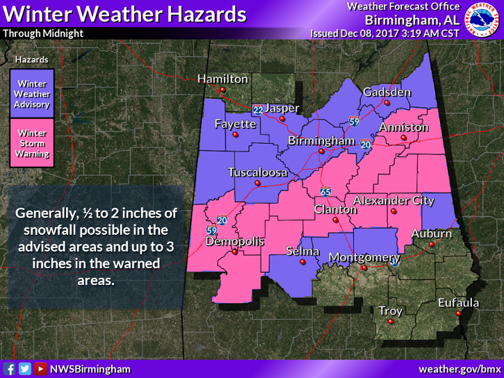
Winter Weather Advisory
URGENT – WINTER WEATHER MESSAGE
National Weather Service Birmingham AL
334 AM CST Thu Dec 7 2017
…ACCUMULATING LIGHT SNOWFALL EXPECTED BEGINNING EARLY FRIDAY
MORNING…
.Cold air moving in from the northwest will result in rain mixing
with and changing to snow beginning late Thursday night and early
Friday morning. Temperatures are expected to remain just above
freezing while the snow falls, which will prevent significant
accumulations, but some light accumulations will be possible
primarily on grassy and elevated surfaces.
ALZ019-021-023>041-043-071745-
/O.NEW.KBMX.WW.Y.0001.171208T0900Z-171209T0000Z/
Calhoun-Cleburne-Tuscaloosa-Jefferson-Shelby-St. Clair-Talladega-
Clay-Randolph-Sumter-Greene-Hale-Perry-Bibb-Chilton-Coosa-
Tallapoosa-Chambers-Marengo-Dallas-Autauga-Elmore-
Including the cities of Anniston, Heflin, Tuscaloosa, Birmingham,
Hoover, Columbiana, Pelham, Alabaster, Pell City, Moody,
Talladega, Sylacauga, Ashland, Roanoke, Livingston, Eutaw,
Greensboro, Moundville, Marion, Centreville, Clanton, Rockford,
Alexander City, Dadeville, Valley, Lanett, Lafayette, Demopolis,
Linden, Selma, Prattville, Wetumpka, and Tallassee
334 AM CST Thu Dec 7 2017
…WINTER WEATHER ADVISORY IN EFFECT FROM 3 AM TO 6 PM CST
FRIDAY…
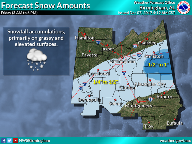
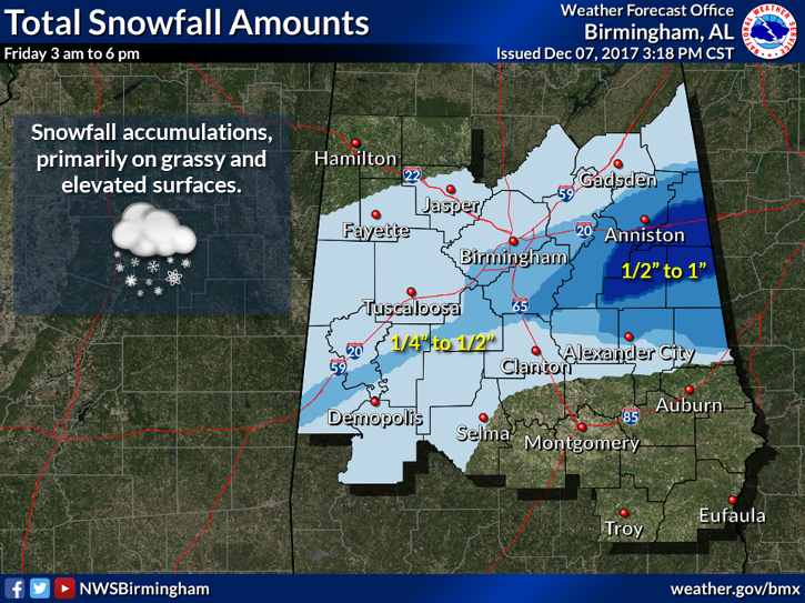
* WHAT…Snow expected. Total accumulations of a quarter to a half
inch are expected, primarily on grassy and elevated surfaces,
with locally higher accumulations up to 1 inch possible in the
higher elevations of East Alabama.
* WHERE…Portions of central, east central and west central
Alabama.
* WHEN…From 3 AM to 6 PM CST Friday.
PRECAUTIONARY/PREPAREDNESS ACTIONS…
A Winter Weather Advisory for snow means periods of snow will
cause primarily travel difficulties. Be prepared for snow covered
roads and limited visibilities, and use caution while driving.