Update on the severe weather threat for Elmore County for today 2-7-17 through tomorrow 2-8-17

08:20:35  According to the National Weather Service (NWS) Weather Forecast Office in Birmingham there is a limited threat of severe storms for much of Central Alabama late morning through the afternoon. The threats include damaging winds, large hail, and an isolated tornado. At this time the current timing forecast is from 9 a.m. through 7 p.m. with the primary time for the severe weather being from about 3:00 p.m. to about 6:00 p.m.

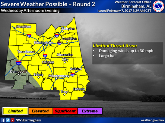
There is also a minimal limited threat of severe storms Wednesday afternoon and evening for much of Central Alabama. If storms can develop, the threats will include damaging winds and large hail. They will refine the area and timing as we get closer to the weather event tomorrow.

You will find the Hazardous Weather Outlook along with a couple of graphics from the NWS below. The graphics describe the threats we may see along with information on the timing of the severe threat that we may see.


HAZARDOUS WEATHER OUTLOOK
NATIONAL WEATHER SERVICE BIRMINGHAM AL

616 AM CST TUE FEB 7 2017

“THIS HAZARDOUS WEATHER OUTLOOK IS FOR THE COUNTIES SERVED BY THE
NATIONAL WEATHER SERVICE OFFICE IN BIRMINGHAM.

.DAY ONE…OUTLOOK THROUGH TONIGHT.

THERE IS A LOW CONFIDENCE THREAT FOR SEVERE THUNDERSTORMS, INCLUDING
DAMAGING WINDS, LARGE HAIL, AND AN ISOLATED TORNADO ACROSS MUCH OF
CENTRAL ALABAMA BETWEEN 9 AM AND 7 PM THIS EVENING.

.DAYS TWO THROUGH SEVEN…WEDNESDAY THROUGH MONDAY.

A SECOND SYSTEM COULD BRING A LOW END THREAT OF DAMAGING WINDS
AND LARGE HAIL FOR WEDNESDAY AFTERNOON AND EVENING ACROSS MUCH
OF CENTRAL ALABAMA AS A COLD FRONT MOVES THROUGH THE AREA.

.SPOTTER INFORMATION STATEMENT…

ACTIVATION OF STORM SPOTTERS AND EMERGENCY MANAGEMENT MAY BE
NECESSARY ON THIS AFTERNOON AND AGAIN ON WEDNESDAY.”


Please do not hesitate to give us a call if you need any additional information or if you have any questions.


Limited severe weather threat for Elmore County over the next couple of days (2-6-17 through 2-8-17)

According to the National Weather Service Weather Forecast Office in Birmingham there is a limited threat of severe storms for much of central Alabama Tuesday afternoon through early Tuesday night. The threats include damaging winds, large hail, and an isolated tornado. Current timing forecast is from 12 noon through 8 pm Tuesday.

There is also a limited threat of severe storms Wednesday afternoon and evening across all of Central Alabama. The threats will include damaging winds and large hail. The NWS will refine the area and timing as we get closer to Wednesday.


Results from the National Weather Service Storm Survey issued 1/25/2017

Trending Now Icon 2

Elmore County was affected by three tornadoes on Saturday, January 21, 2017.

The Wetumpka (downtown) and Willow Springs Road tornadoes were each rated “EF-1”. The Emerald Mountain Christian School tornado was rated “EF-0”.

The below graphic shows confirmed tornadoes as a result of storm damage surveys conducted by the NWS

 Storm Servey 1232017

NWS Surveying Elmore County Storm Damages This A.M. 1/24/2017

8:43:26 AM   National Weather Service (NWS) Weather Forecast Office Birmingham, Meteorologist in Charge John De Block, accompanied by Senior Meteorologist Mary Keiser, is in Elmore County this morning to survey storm damages from this weekend’s severe storms. Surveys are conducted to determine, among other things, whether storm damages are caused by straight line winds or tornadoes. Final determinations from the NWS Survey will be posted on EMA’s website once they are made available to this office.

If anyone has UNREPORTED storm damages, please contact the Elmore County EMA As Soon As Possible (ASAP) at 334-567-6451 so that those damages may be included in this storm report!

Current Road Conditions in Elmore

Trending Now Icon 2

As of 7:30 P.M. 1/22/2017

Peace Church Road from Rifle Range  Road to Mitchell Creek Road has re-opened. Citizens should avoid this area until further notice due to power restoration activities. Please be mindful of utility crews working in the area.

Harris Road in Elmore – the dirt section is closed until further notice.

Cain Road from Hwy 111 to Nixon Lane is closed until further notice.